TERMINALIA
first performed on July 1, 2016
Grüntaler9, Berlin, Germany
performed once in 2016
PATRICK MONTE
Oakland, CA
844940018p844940018m844940018o844940018n844940018t844940018e844940018@844940018x844940018u844940018p844940018s844940018t844940018a844940018r844940018.844940018c844940018o844940018m
patrickmonte.com
TERMINALIA
PATRICK MONTE
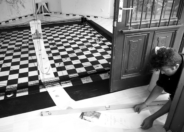
“Terminalia” was a series of three interdependent eight hour durational performance works, historic techniques, and practices of land surveying and boundary making. The triptych took its name from an ancient Roman festival held annually in honor of the god of boundary stones, Terminus, during which stones marking the meeting of estates would be consecrated with first harvests, wine, and honey. Boundary stones and monuments have been observed across histories and cultures, and in the 19th century became a means of establishing triangulation networks used in modern cartography and land surveying (forerunners to GPS technology). “Terminalia” sought to transform Grüntaler9 into an alternative cartographic space with the aim of destabilizing conceptions of boundaries, be they mathematical, social, or personal.
The first performance, “550-Meter GeoSpirit Overlay,” transformed space by imposing a geometric and symbolic order. An 8 x 8 x 36” concrete block was placed at the center of the space, and four cinder blocks were placed in a square around it. A screen with an activated camera was placed atop the centerpiece and set to run constantly—a reference to ancient Roman sculptural Terms. Five hundred and fifty meters of black and white tape were laid on the floor in a square formation.
The second performance, “Over a Kilometer of Learning and Unlearning How to Move,” transformed the body through bound space. I walked in a continuous square formation along the black boundary path established in the first performance and stopped at each corner to bind my body in black yarn. After binding my upper body and head with over a kilometer of yarn, suction cup nodes were placed in the center of the space. Using these nodes, I bound myself into a triangulation network along the original black boundary path, and wrapped the corner stones in yarn.
The third performance, “Paper Bounds,” considered the mathematical and informational production of borders. The performance utilized a photocopy of an 1890s re-survey of the Mexico-US international boundary containing land descriptions, charts of astronomical observations, mathematical calculations, and photographs of monuments used to mark and determine the boundary. I taped pages to the ground in the gallery forming a line stretching to a nearby public park monument. I then drew a red triangulation network which connected all of the pages and placed a handful of sand on each page. I then coated my feet in blue paint and walked along the pages back to the gallery and kicked down its central monument.